CORDEX domains#
The domain module should give some tools to work with preconfigured or user defined domains. Domains are defined as xarray datasets that will contain dimensions and coodinates according to CF-conventions.
NOTE: The domain module mostly focuses on working with rotated cordex domains and how they are defined in the cordex archive specifications. However, there are some regional models that use different mappings instead of rotated_pole or rotated_latitude_longitude which we focus on. Any expertise working with those different mappings is highly welcome!
[1]:
import cordex as cx
The domain module contains some useful functions to work with cordex meta data, e.g., you can get some domain grid information using
[2]:
cx.domain_info("EUR-11")
[2]:
{'short_name': 'EUR-11',
 'region': 4,
 'domain_id': 'EUR-12',
 'domain': 'Europe',
 'CORDEX_domain': 'EUR-11',
 'long_name': 'Europe',
 'nlon': 424,
 'nlat': 412,
 'll_lon': -28.375,
 'ur_lon': 18.155,
 'll_lat': -23.375,
 'ur_lat': 21.835,
 'dlon': 0.11,
 'dlat': 0.11,
 'pollon': -162.0,
 'pollat': 39.25}
All available cordex domains can be found in the CORDEX domain table on github or directly from withing py-cordex, e.g.
[3]:
cx.tables.domains
[3]:
| region | domain_id | domain | CORDEX_domain | long_name | nlon | nlat | ll_lon | ur_lon | ll_lat | ur_lat | dlon | dlat | pollon | pollat | |
|---|---|---|---|---|---|---|---|---|---|---|---|---|---|---|---|
| short_name | |||||||||||||||
| SAM-44 | 1 | SAM-50 | South America | SAM-44 | South America | 146 | 167 | 143.92000 | 207.72000 | -38.28000 | 34.76000 | 0.4400 | 0.4400 | -56.06 | 70.60 |
| CAM-44 | 2 | CAM-50 | Central America | CAM-44 | Central America | 210 | 113 | -52.80000 | 39.16000 | -28.60000 | 20.68000 | 0.4400 | 0.4400 | 113.98 | 75.74 |
| NAM-44 | 3 | NAM-50 | North America | NAM-44 | North America | 155 | 130 | -33.88000 | 33.88000 | -28.40000 | 28.36000 | 0.4400 | 0.4400 | 83.00 | 42.50 |
| EUR-44 | 4 | EUR-50 | Europe | EUR-44 | Europe | 106 | 103 | -28.21000 | 17.99000 | -23.21000 | 21.67000 | 0.4400 | 0.4400 | -162.00 | 39.25 |
| AFR-44 | 5 | AFR-50 | Africa | AFR-44 | Africa | 194 | 201 | -24.64000 | 60.28000 | -45.76000 | 42.24000 | 0.4400 | 0.4400 | 180.00 | 90.00 |
| WAS-44 | 6 | WAS-50 | South Asia | WAS-44 | South Asia | 193 | 130 | -32.12000 | 52.36000 | -21.56000 | 35.20000 | 0.4400 | 0.4400 | -123.34 | 79.95 |
| EAS-44 | 7 | EAS-50 | East Asia | EAS-44 | East Asia | 203 | 167 | -40.92000 | 47.96000 | -26.84000 | 46.20000 | 0.4400 | 0.4400 | -64.78 | 77.61 |
| CAS-44 | 8 | CAS-50 | Central Asia | CAS-44 | Central Asia | 153 | 100 | -34.32000 | 32.56000 | -20.68000 | 22.88000 | 0.4400 | 0.4400 | -103.39 | 43.48 |
| AUS-44 | 9 | AUS-50 | Australasia | AUS-44 | Australasia | 200 | 129 | 142.16000 | 229.72000 | -22.88000 | 33.44000 | 0.4400 | 0.4400 | 141.38 | 60.31 |
| ANT-44 | 10 | ANT-50 | Antarctica | ANT-44 | Antarctica | 125 | 97 | 152.72000 | 207.28000 | -27.72000 | 14.52000 | 0.4400 | 0.4400 | -166.92 | 6.08 |
| ARC-44 | 11 | ARC-50 | Arctic | ARC-44 | Arctic | 116 | 133 | -22.88000 | 27.72000 | -24.20000 | 33.88000 | 0.4400 | 0.4400 | 0.00 | 6.55 |
| MED-44 | 12 | MED-50 | Mediterranean | MED-44 | Mediterranean | 98 | 63 | -23.22000 | 19.46000 | -21.34000 | 5.94000 | 0.4400 | 0.4400 | 198.00 | 39.25 |
| MNA-44 | 13 | MNA-50 | Middle East and North Africa | MNA-44 | Middle East and North Africa | 232 | 118 | -26.40000 | 75.24000 | -6.60000 | 44.88000 | 0.4400 | 0.4400 | 180.00 | 90.00 |
| MNA-22 | 13 | MNA-25 | Middle East and North Africa | MNA-22 | Middle East and North Africa | 464 | 236 | -26.51000 | 75.35000 | -6.71000 | 44.99000 | 0.2200 | 0.2200 | 180.00 | 90.00 |
| SAM-11 | 1 | SAM-12 | South America | SAM-11 | South America | 584 | 668 | 143.75500 | 207.88500 | -38.44500 | 34.92500 | 0.1100 | 0.1100 | -56.06 | 70.60 |
| CAM-11 | 2 | CAM-12 | Central America | CAM-11 | Central America | 840 | 452 | -52.96500 | 39.32500 | -28.76500 | 20.84500 | 0.1100 | 0.1100 | 113.98 | 75.74 |
| NAM-11 | 3 | NAM-12 | North America | NAM-11 | North America | 620 | 520 | -34.04500 | 34.04500 | -28.56500 | 28.52500 | 0.1100 | 0.1100 | 83.00 | 42.50 |
| EUR-11 | 4 | EUR-12 | Europe | EUR-11 | Europe | 424 | 412 | -28.37500 | 18.15500 | -23.37500 | 21.83500 | 0.1100 | 0.1100 | -162.00 | 39.25 |
| AFR-11 | 5 | AFR-12 | Africa | AFR-11 | Africa | 776 | 804 | -24.80500 | 60.44500 | -45.92500 | 42.40500 | 0.1100 | 0.1100 | 180.00 | 90.00 |
| WAS-11 | 6 | WAS-12 | South Asia | WAS-11 | South Asia | 772 | 520 | -32.28500 | 52.52500 | -21.72500 | 35.36500 | 0.1100 | 0.1100 | -123.34 | 79.95 |
| EAS-11 | 7 | EAS-12 | East Asia | EAS-11 | East Asia | 812 | 668 | -41.08500 | 48.12500 | -27.00500 | 46.36500 | 0.1100 | 0.1100 | -64.78 | 77.61 |
| CAS-11 | 8 | CAS-12 | Central Asia | CAS-11 | Central Asia | 612 | 400 | -34.48500 | 32.72500 | -20.84500 | 23.04500 | 0.1100 | 0.1100 | -103.39 | 43.48 |
| AUS-11 | 9 | AUS-12 | Australasia | AUS-11 | Australasia | 800 | 516 | 141.99500 | 229.88500 | -23.04500 | 33.60500 | 0.1100 | 0.1100 | 141.38 | 60.31 |
| ANT-11 | 10 | ANT-12 | Antarctica | ANT-11 | Antarctica | 500 | 388 | 152.55500 | 207.44500 | -27.88500 | 14.68500 | 0.1100 | 0.1100 | -166.92 | 6.08 |
| ARC-11 | 11 | ARC-12 | Arctic | ARC-11 | Arctic | 464 | 532 | -23.04500 | 27.88500 | -24.36500 | 34.04500 | 0.1100 | 0.1100 | 0.00 | 6.55 |
| MED-11 | 12 | MED-12 | Mediterranean | MED-11 | Mediterranean | 392 | 252 | -23.38500 | 19.62500 | -21.50500 | 6.10500 | 0.1100 | 0.1100 | 198.00 | 39.25 |
| MNA-11 | 13 | MNA-12 | Middle East and North Africa | MNA-11 | Middle East and North Africa | 928 | 472 | -26.56500 | 75.40500 | -6.76500 | 45.04500 | 0.1100 | 0.1100 | 180.00 | 90.00 |
| GAR-0275 | 4 | GAR-3 | Greater Alpine Region | GAR-0275 | Greater Alpine Region | 476 | 444 | -13.51125 | -0.44875 | -10.93125 | 1.25125 | 0.0275 | 0.0275 | -162.00 | 39.25 |
| CEU-0275 | 4 | CEU-3 | Central Europe | CEU-0275 | Central Europe | 345 | 385 | -9.30375 | NaN | -5.07375 | NaN | 0.0275 | 0.0275 | -162.00 | 39.25 |
| MEU-0275 | 4 | MEU-3 | Mid Europe | MEU-0275 | Mid Europe | 501 | 501 | -12.30000 | NaN | -6.90000 | NaN | 0.0275 | 0.0275 | -162.00 | 39.25 |
| SAM-22 | 1 | SAM-25 | South America | SAM-22 | South America | 292 | 334 | 143.81000 | 207.83000 | -38.39000 | 34.87000 | 0.2200 | 0.2200 | -56.06 | 70.60 |
| CAM-22 | 2 | CAM-25 | Central America | CAM-22 | Central America | 420 | 226 | -52.91000 | 39.27000 | -28.71000 | 20.79000 | 0.2200 | 0.2200 | 113.98 | 75.74 |
| NAM-22 | 3 | NAM-25 | North America | NAM-22 | North America | 310 | 260 | -33.99000 | 33.99000 | -28.51000 | 28.47000 | 0.2200 | 0.2200 | 83.00 | 42.50 |
| EUR-22 | 4 | EUR-25 | Europe | EUR-22 | Europe | 212 | 206 | -28.32000 | 18.10000 | -23.32000 | 21.78000 | 0.2200 | 0.2200 | -162.00 | 39.25 |
| AFR-22 | 5 | AFR-25 | Africa | AFR-22 | Africa | 388 | 402 | -24.75000 | 60.39000 | -45.87000 | 42.35000 | 0.2200 | 0.2200 | 180.00 | 90.00 |
| WAS-22 | 6 | WAS-25 | South Asia | WAS-22 | South Asia | 386 | 260 | -32.23000 | 52.47000 | -21.67000 | 35.31000 | 0.2200 | 0.2200 | -123.34 | 79.95 |
| EAS-22 | 7 | EAS-25 | East Asia | EAS-22 | East Asia | 396 | 251 | -43.23000 | 43.67000 | -22.10000 | 32.90000 | 0.2200 | 0.2200 | -64.78 | 77.61 |
| CAS-22 | 8 | CAS-25 | Central Asia | CAS-22 | Central Asia | 306 | 200 | -34.43000 | 32.67000 | -20.79000 | 22.99000 | 0.2200 | 0.2200 | -103.39 | 43.48 |
| AUS-22 | 9 | AUS-25 | Australasia | AUS-22 | Australasia | 400 | 258 | 142.05000 | 229.83000 | -22.99000 | 33.55000 | 0.2200 | 0.2200 | 141.38 | 60.31 |
| SEA-22 | 14 | SEA-25 | South East Asia | SEA-22 | South East Asia | 264 | 194 | 89.26000 | 147.12000 | -15.18000 | 27.28000 | 0.2200 | 0.2200 | 180.00 | 90.00 |
| SEA-11 | 14 | SEA-12 | South East Asia | SEA-11 | South East Asia | 528 | 388 | 89.20500 | NaN | -15.23500 | NaN | 0.1100 | 0.1100 | 180.00 | 90.00 |
| SAM-44i | 1 | SAM-50i | South America | SAM-44i | South America | 181 | 155 | -106.25000 | -16.25000 | -58.25000 | 18.75000 | 0.5000 | 0.5000 | NaN | NaN |
| CAM-44i | 2 | CAM-50i | Central America | CAM-44i | Central America | 207 | 111 | -124.75000 | -21.75000 | -19.75000 | 35.25000 | 0.5000 | 0.5000 | NaN | NaN |
| NAM-44i | 3 | NAM-50i | North America | NAM-44i | North America | 300 | 129 | -171.75000 | -22.25000 | 12.25000 | 76.25000 | 0.5000 | 0.5000 | NaN | NaN |
| EUR-44i | 4 | EUR-50i | Europe | EUR-44i | Europe | 221 | 103 | -44.75000 | 65.25000 | 21.75000 | 72.75000 | 0.5000 | 0.5000 | NaN | NaN |
| AFR-44i | 5 | AFR-50i | Africa | AFR-44i | Africa | 173 | 179 | -25.25000 | 60.75000 | -46.25000 | 42.75000 | 0.5000 | 0.5000 | NaN | NaN |
| WAS-44i | 6 | WAS-50i | South Asia | WAS-44i | South Asia | 195 | 124 | 19.25000 | 116.25000 | -15.75000 | 45.75000 | 0.5000 | 0.5000 | NaN | NaN |
| EAS-44i | 7 | EAS-50i | East Asia | EAS-44i | East Asia | 227 | 157 | 62.75000 | 175.75000 | -18.75000 | 59.25000 | 0.5000 | 0.5000 | NaN | NaN |
| CAS-44i | 8 | CAS-50i | Central Asia | CAS-44i | Central Asia | 260 | 133 | 10.75000 | 140.25000 | 17.75000 | 69.75000 | 0.5000 | 0.5000 | NaN | NaN |
| AUS-44i | 9 | AUS-50i | Australasia | AUS-44i | Australasia | 238 | 133 | 88.75000 | 207.25000 | -53.25000 | 12.75000 | 0.5000 | 0.5000 | NaN | NaN |
| ANT-44i | 10 | ANT-50i | Antarctica | ANT-44i | Antarctica | 720 | 70 | -179.75000 | 179.75000 | -89.75000 | -55.25000 | 0.5000 | 0.5000 | NaN | NaN |
| ARC-44i | 11 | ARC-50i | Arctic | ARC-44i | Arctic | 720 | 83 | -179.75000 | 179.75000 | 48.75000 | 89.75000 | 0.5000 | 0.5000 | NaN | NaN |
| MED-44i | 12 | MED-50i | Mediterranean | MED-44i | Mediterranean | 144 | 65 | -20.75000 | 51.75000 | 25.25000 | 57.25000 | 0.5000 | 0.5000 | NaN | NaN |
| MNA-44i | 13 | MNA-50i | Middle East and North Africa | MNA-44i | Middle East and North Africa | 206 | 106 | -26.75000 | 75.75000 | -7.25000 | 45.25000 | 0.5000 | 0.5000 | NaN | NaN |
| MNA-22i | 13 | MNA-25i | Middle East and North Africa high res. | MNA-22i | Middle East and North Africa high res. | 410 | 209 | -26.62500 | 75.62500 | -6.87500 | 45.12500 | 0.2500 | 0.2500 | NaN | NaN |
| EUR-11i | 4 | EUR-12i | Europe high res. | EUR-11i | Europe high res. | 881 | 408 | -44.81250 | 65.18750 | 21.81250 | 72.68750 | 0.1250 | 0.1250 | NaN | NaN |
| SEA-22i | 14 | SEA-25i | South East Asia | SEA-22i | South East Asia | 233 | 172 | 89.12500 | 147.12500 | -15.37500 | 27.37500 | 0.2500 | 0.2500 | NaN | NaN |
EUR-11 example#
The heart of the module are some functions that create a dataset from the grid information, e.g.
[4]:
eur11 = cx.cordex_domain("EUR-11", dummy="topo")
eur11
/home/docs/checkouts/readthedocs.org/user_builds/py-cordex/conda/latest/lib/python3.10/site-packages/cf_xarray/accessor.py:718: FutureWarning: The return type of `Dataset.dims` will be changed to return a set of dimension names in future, in order to be more consistent with `DataArray.dims`. To access a mapping from dimension names to lengths, please use `Dataset.sizes`.
  unused_keys = set(attribute.keys()) - set(inverted)
/home/docs/checkouts/readthedocs.org/user_builds/py-cordex/conda/latest/lib/python3.10/site-packages/cf_xarray/accessor.py:719: FutureWarning: The return type of `Dataset.dims` will be changed to return a set of dimension names in future, in order to be more consistent with `DataArray.dims`. To access a mapping from dimension names to lengths, please use `Dataset.sizes`.
  for key, value in attribute.items():
[4]:
<xarray.Dataset> Size: 4MB
Dimensions:                     (rlon: 424, rlat: 412)
Coordinates:
  * rlon                        (rlon) float64 3kB -28.38 -28.27 ... 18.05 18.16
  * rlat                        (rlat) float64 3kB -23.38 -23.27 ... 21.73 21.84
    lon                         (rlat, rlon) float64 1MB -10.06 -9.964 ... 64.96
    lat                         (rlat, rlon) float64 1MB 21.99 22.03 ... 66.69
Data variables:
    rotated_latitude_longitude  int32 4B 0
    topo                        (rlat, rlon) float32 699kB 284.0 246.0 ... 509.0
Attributes:
CORDEX_domain: EUR-11The dummy='topo' argument means, we want a dummy variable in the dataset to see how the domain looks like. For the dummy topography, we use the cdo topo operator in the background. So maybe you have to install python-cdo, e.g., conda install -c conda-forge python-cdo. Working with xarray datasets means, that we can use all the nice functions of xarray including plotting, e.g.,
[5]:
eur11.topo.plot(cmap="terrain")
[5]:
<matplotlib.collections.QuadMesh at 0x782e1becd840>
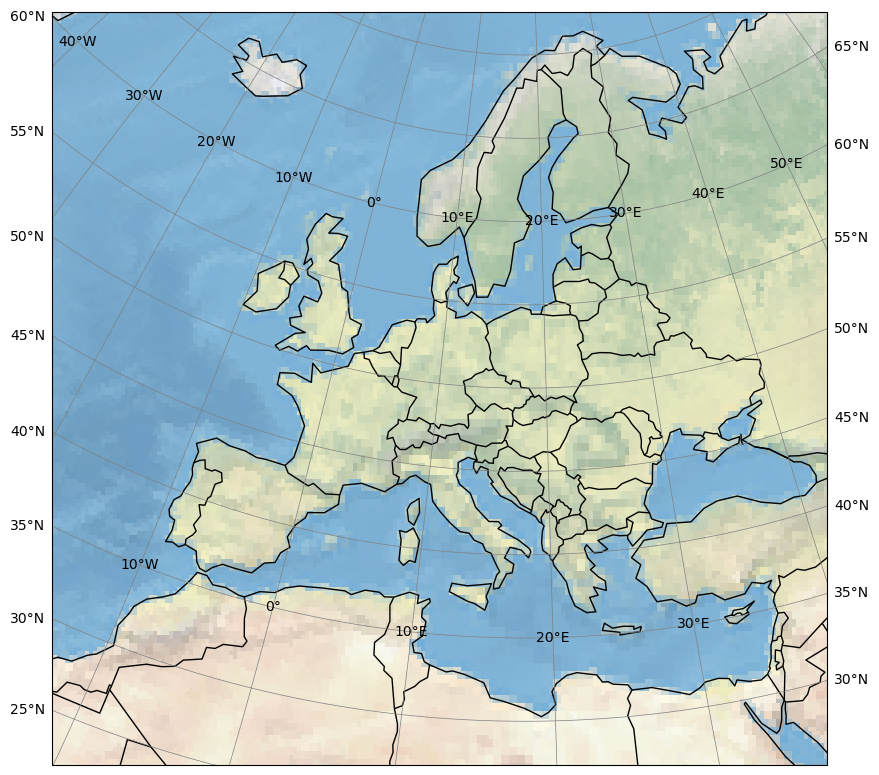
py-cordex also provides some xarray accessor functions. E.g., to get an overview of a domain, you can use the ds.cx.map function:
[6]:
import matplotlib.pyplot as plt

plt.figure(figsize=(10, 10))
eur11.cx.map()
/home/docs/checkouts/readthedocs.org/user_builds/py-cordex/conda/latest/lib/python3.10/site-packages/cartopy/mpl/feature_artist.py:143: UserWarning: facecolor will have no effect as it has been defined as "never".
  warnings.warn('facecolor will have no effect as it has been '
[6]:
<GeoAxes: >
/home/docs/checkouts/readthedocs.org/user_builds/py-cordex/conda/latest/lib/python3.10/site-packages/cartopy/io/__init__.py:242: DownloadWarning: Downloading: https://naturalearth.s3.amazonaws.com/110m_physical/ne_110m_coastline.zip
  warnings.warn(f'Downloading: {url}', DownloadWarning)
/home/docs/checkouts/readthedocs.org/user_builds/py-cordex/conda/latest/lib/python3.10/site-packages/cartopy/io/__init__.py:242: DownloadWarning: Downloading: https://naturalearth.s3.amazonaws.com/110m_cultural/ne_110m_admin_0_boundary_lines_land.zip
  warnings.warn(f'Downloading: {url}', DownloadWarning)
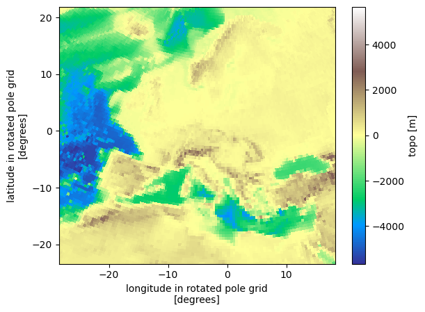
Let’s define a slightly more sophisticated plotting function that uses cartopy for the right projection with a rotated pole:
[7]:
import cartopy.crs as ccrs
import cartopy.feature as cf
import matplotlib.pyplot as plt


def plot(
    da,
    transform=ccrs.PlateCarree(),
    projection=ccrs.PlateCarree(),
    vmin=None,
    vmax=None,
    borders=True,
    xlocs=range(-180, 180, 10),
    ylocs=range(-90, 90, 5),
    extent=None,
    figsize=(15, 10),
    title="",
):
    """plot a domain using the right projections and transformations with cartopy"""
    plt.figure(figsize=figsize)
    ax = plt.axes(projection=projection)
    if extent:
        ax.set_extent(extent, crs=projection)
    ax.gridlines(
        draw_labels=True, linewidth=0.5, color="gray", xlocs=xlocs, ylocs=ylocs
    )
    da.plot(ax=ax, cmap="terrain", transform=transform, vmin=vmin, vmax=vmax)
    ax.coastlines(resolution="50m", color="black", linewidth=1)
    if borders:
        ax.add_feature(cf.BORDERS)
    return ax
We can now use the grid mapping information to plot the data in it’s native coordinate system using cartopy:
[8]:
pole = (
    eur11.rotated_latitude_longitude.grid_north_pole_longitude,
    eur11.rotated_latitude_longitude.grid_north_pole_latitude,
)
pole
[8]:
(-162.0, 39.25)
[9]:
plot(eur11.topo, transform=ccrs.RotatedPole(*pole), projection=ccrs.RotatedPole(*pole))
[9]:
<GeoAxes: xlabel='longitude in rotated pole grid\n[degrees]', ylabel='latitude in rotated pole grid\n[degrees]'>
/home/docs/checkouts/readthedocs.org/user_builds/py-cordex/conda/latest/lib/python3.10/site-packages/cartopy/io/__init__.py:242: DownloadWarning: Downloading: https://naturalearth.s3.amazonaws.com/50m_physical/ne_50m_coastline.zip
  warnings.warn(f'Downloading: {url}', DownloadWarning)

User defined domain#
The domains are actually created from a csv table that define standard cordex domains. E.g., the data used to created the EUR-11 domain is
[10]:
cx.tables.domains.loc["EUR-11"]
[10]:
region                4
domain_id        EUR-12
domain           Europe
CORDEX_domain    EUR-11
long_name        Europe
nlon                424
nlat                412
ll_lon          -28.375
ur_lon           18.155
ll_lat          -23.375
ur_lat           21.835
dlon               0.11
dlat               0.11
pollon           -162.0
pollat            39.25
Name: EUR-11, dtype: object
The domains are created using the create_dataset function, e.g.:
[11]:
eur11_user = cx.create_dataset(
    nlon=424,
    nlat=412,
    dlon=0.11,
    dlat=0.11,
    ll_lon=-28.375,
    ll_lat=-23.375,
    pollon=-162.00,
    pollat=39.25,
    dummy="topo",
)
/home/docs/checkouts/readthedocs.org/user_builds/py-cordex/conda/latest/lib/python3.10/site-packages/cf_xarray/accessor.py:718: FutureWarning: The return type of `Dataset.dims` will be changed to return a set of dimension names in future, in order to be more consistent with `DataArray.dims`. To access a mapping from dimension names to lengths, please use `Dataset.sizes`.
  unused_keys = set(attribute.keys()) - set(inverted)
/home/docs/checkouts/readthedocs.org/user_builds/py-cordex/conda/latest/lib/python3.10/site-packages/cf_xarray/accessor.py:719: FutureWarning: The return type of `Dataset.dims` will be changed to return a set of dimension names in future, in order to be more consistent with `DataArray.dims`. To access a mapping from dimension names to lengths, please use `Dataset.sizes`.
  for key, value in attribute.items():
We can check that this gives the same result as our preconfigured domain.
[12]:
eur11_user.equals(eur11)
[12]:
True